A COMPASS FOR COMPLEX FIELD DATA
Integrate Data by
Location and Structure
Send commands to connected applications at registered map locations
Link captured images to maps, target structures, and documents for integrated management
A desktop application for use in the field and the office
Manage Waypoints, Areas, and Your Current Position on One Map
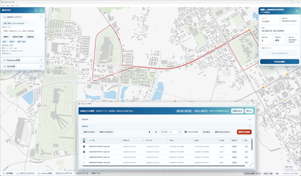
GigaScope Atlas works with GigaScope Capture to carry out planned imaging at predefined locations.
It also brings field additions and corrections, historical data, and reference documents together on the same map.
Use one consistent interface for pre-work review, location awareness during the day, and post-work history management.
Information Managed by Atlas
- Waypoints: view and correct registered positions, add entries, and manage groups
- Geofences: register circular or polygonal areas and detect entry and exit events
- GNSS: display the current position, check positioning status, and record movement history
- Tracks: reopen and replay saved sessions, with CSV import and export
- External integration: monitor capture-job requests and callback responses
Organize Waypoint Data for Your Field Workflow
Review, Correct, and Add Waypoints
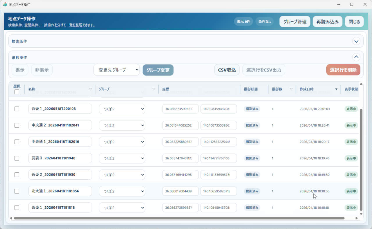
- Review data and attributes imported from connected applications on the map
- Register waypoints and correct coordinates directly on the map
- Use text search, spatial filtering, bulk actions, and in-table editing
- Review multiple waypoints sequentially during a patrol
Use Geofence Events to Trigger External Actions
Define Areas and Detect Entry or Exit
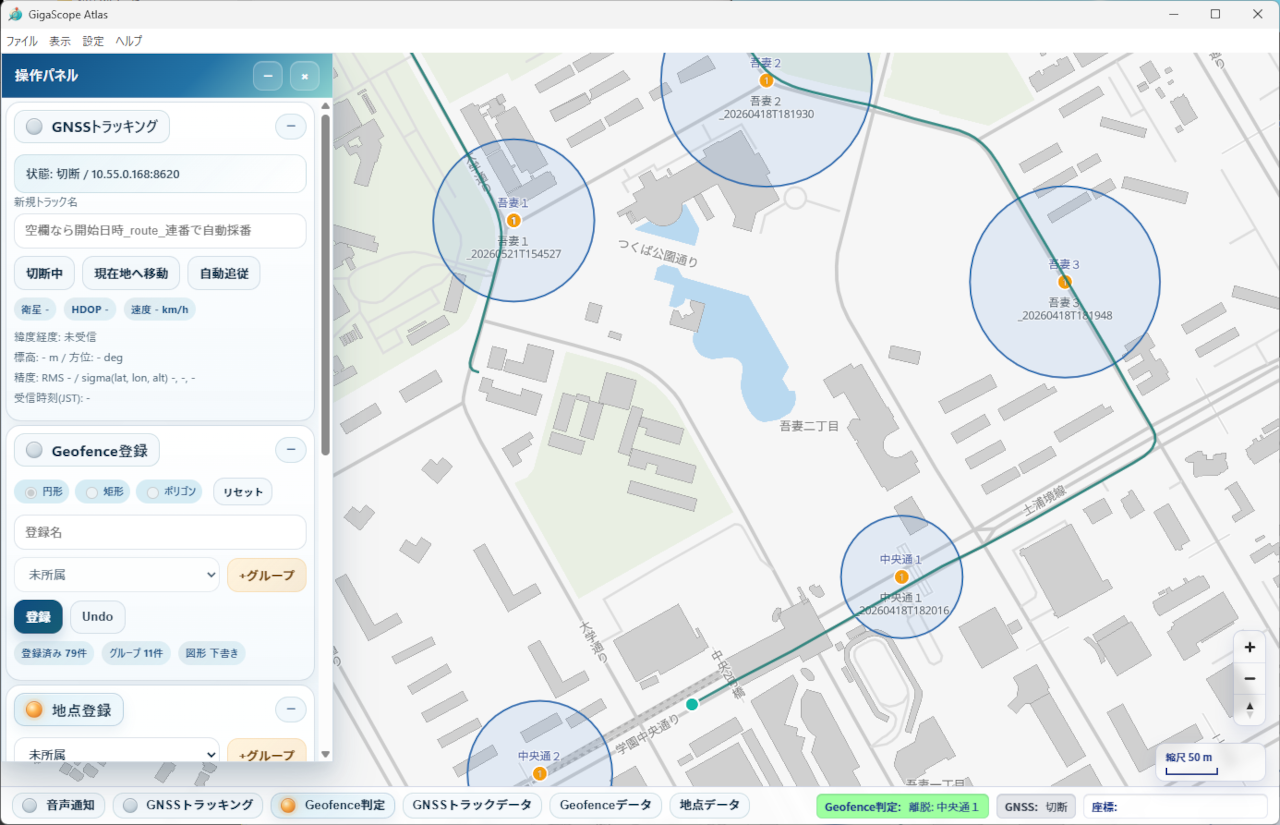
- Draw circular or polygonal geofences on the map
- Manage visibility, activation, removal, and CSV import or export by group
- Immediately check whether a selected coordinate or current GNSS position is inside an area
- View stopped, awaiting fix, outside, entered, and exited states in the status bar
- Use geofence results to start or stop capture on an external device
A Workflow Designed for Field Operations
From Setup to Final Review
Before operations begin, configure the PMTiles basemap, GNSS endpoint, receiving mode, target devices, and bearer tokens.
Display the required waypoint and geofence groups. When using GNSS, verify positioning and track recording before starting work.
Stop GNSS tracking, then review the day's route, requests sent to external devices, selections, and display states before closing the application.
External Integration
- Configure callback reception for local, same-network, or public base URLs
- Manage the base URL, enabled state, timeout, and bearer token for each external device
- Choose the target geofence group and coordinate type for each destination
- Use test events to verify both the outbound request path and callback response path
- Use trusted networks and token-based access for LAN listeners and capture APIs
FAQ
You can also reach us through the contact form. We will be happy to help.
What does GigaScope Atlas do?
GigaScope Atlas is a GIS desktop application for Windows that displays waypoints, geofences, the current GNSS position, and GNSS tracks together on a map. It supports field waypoint review, area detection, movement history recording, and integration with external devices.
How are basemaps configured?
Atlas uses a PMTiles file as its basemap. The recommended location is %APPDATA%/gigascope-atlas/mapdata/japan.pmtiles. You can review or change the path in Settings.
Are connecting to GNSS and recording a track the same operation?
No. Simply connecting to GNSS and displaying the current position does not save a history. To retain movement history, enter a session name if required and enable GNSS tracking.
What should I check when integrating an external device?
Check the receiving mode, listening address, port, public URL, destination base URL, bearer token, target geofence group, and coordinate type. Before field use, send and receive test events to confirm that both the outbound request path and callback response path work successfully.
Can Atlas exchange data with external systems in CSV format?
Yes. Atlas supports CSV import and export for waypoints, geofences, and GNSS tracks. When exchanging data with an external system, use the official column headers listed in the operation manual to prevent interpretation errors.
Specifications
Overview
GigaScope Atlas is a desktop application for reviewing and organizing waypoints, geofences, and GNSS information used in field operations on a single map. Review and correct waypoints, evaluate geofences, record GNSS movement history, and connect external devices through one consistent interface.
System Requirements
- OS: Windows 10 or 11 (64-bit)
- Memory: 8 GB minimum
- Storage: Sufficient space for the application, SQLite database, and PMTiles basemap
- Network: Required according to your external-device, callback, and GNSS server configuration
- Display: 1920 × 1080 or higher recommended
Key Features
Map Display
- Overlay waypoints, geofences, the current GNSS position, and GNSS tracks
- Select coordinates by clicking and change the visible area by dragging or using the mouse wheel
- Organize the workspace with collapsible control panels and auxiliary windows
Waypoint Management
- Register waypoints, create sequentially numbered waypoints with one click, correct coordinates, and manage groups
- Search, filter, perform bulk actions, and import or export CSV in the waypoint data window
- Review patrol routes by drawing waypoints
Geofence Management
- Register circular and polygonal geofences
- Activate, remove, clear from view, add groups, and import or export CSV data
- Detect entry and exit events for a selected coordinate or the current GNSS position
GNSS Tracking
- Receive the current position from a GNSS server
- Save, reopen, replay, and export tracking sessions as CSV
- Evaluate geofences and provide spoken notifications during track playback
External Integration
- Configure local, private-network, or public-network callback reception
- Manage capture-job destinations for external devices
- Verify connections by sending and receiving test events
Contact
Contact Us
Send us your questions, implementation inquiries, or other requests using the form below.
Contact Form
 https://technohighway.co.jp